
Nevada Exploration Presents Final RC Drilling Results from South Grass Valley Carlin-Type Gold Project
May 27, 2020
Nevada Exploration Inc. (“NGE” or the “Company”) (TSX-V: NGE; OTCQB: NVDEF) is pleased to report that the recently-completed reverse-circulation (“RC”) drilling program at its South Grass Valley Project has focused the Company’s search for new Carlin-type gold deposits (CTGDs) to a mineralized corridor, which the Company believes is the potential common fluid source for three of the four target areas that the program was designed to advance. Having used RC drilling to cost-effectively increase its data coverage at the project, and thus its confidence in its geologic model, NGE is now preparing to return to core drilling to complete a carefully-targeted deeper drilling program to test this corridor, which NGE has named East Golden Gorge, for Carlin-type gold mineralization.
Discussing how the latest drilling program has advanced the project, Wade Hodges, NGE’s CEO: “The objective of our preliminary, 2018-2019 core-drilling program at South Grass Valley, which consisted of 10 core holes spread along nearly four kilometers north-south, was to test for the presence of a Carlin-type mineral system large enough to support one or more multi-million-ounce Carlin-type gold deposits, at what is a completely-covered project that we identified as part of our hydrogeochemistry-led exploration program. Achieving this objective was a big milestone for the project and NGE, though it is important to point out that at the end of this initial program, while we believed we had successfully discovered a large new Carlin-type mineral system, our geologic model was made up of only a couple handfuls of drill holes across an area comparable in size to the entire northern Carlin Trend, in a part of Nevada where geologic features important for mineralization can change quickly, over short distances.
“To continue to advance and de-risk this still early-stage project, the goal for our second round of drilling at South Grass Valley was to establish the major geologic controls for mineralization in order to guide our search for potentially economic deposits, and for this we needed to improve the resolution of our geologic model, which required many more drill holes. To maximize the number of pierce points we could complete, for this second round of drilling we changed to less-expensive RC drilling; and to guide the distribution of these drill holes across the project, we chose to cluster the holes in four discrete target areas, each of which represented places within the district that already showed promise in terms of their specific geologic settings, and that also were supported by elevated gold and Carlin-type pathfinder geochemistry in multiple sample mediums.
“As we shared in our monthly drilling updates, challenging drilling conditions across much of the project - largely the result of a combination of swelling clay plus highly-fractured and intensely-silicified bedrock, proved difficult for the medium-sized RC drill rigs we were using; and a significant number of the RC drill holes did not reach target depth. As a result, we only completed 17 of the approximately 23 planned holes, and in several cases were forced to stop these holes shallower than we had expected. Despite the challenges, with the addition of these 17 new drill holes, we are looking at an almost three-fold increase to our total number of drill holes at South Grass Valley, which has considerably sharpened our understanding of the geology across the project.
“We believe strongly that geology is what is going to drive any discovery at South Grass Valley, and as we’ve shared, our goal at this stage of the project was essentially to establish what controlled the hydrothermal fluid flow responsible for the mineralization. The combined results of our two drilling programs have now given us multiple lines of evidence that at two of the four target areas, Freddie and Golden Gorge, the mineralized hydrothermal fluid flow was focused along a specific stratigraphic bedrock unit we call the Clm Unit, and that the direction of fluid flow at these targets appears to have come from a common source area, which we have named East Golden Gorge, located immediately west of a major structural corridor. Our third target area, Water Canyon, is located parallel to this same structural corridor and similarly up dip of the projected southern extension of East Golden Gorge, and while we’ve only completed two drill holes here so far, the results have provided some early geochemistry support that the geologic features responsible for East Golden Gorge could extend considerably further to the south. At our fourth target area, Waterfall, the results of the RC drilling helped to improve our overall geologic model, but do not support continued work in this target area.
“In summary, despite completing a smaller program than planned, with our 2020 RC drilling: we meaningfully advanced two of the four target areas (Freddie and Golden Gorge), which are resolving into a single deeper target in the East Golden Gorge area; we collected initial drill samples in a third target area (Water Canyon) along the projected extension of East Golden Gorge; and we effectively killed the fourth target area (Waterfall), which helps us to now narrow our focus to East Golden Gorge, which we believe represents the shared source of the shallower expressions we’re seeing at the remaining targets areas.
“Having established the likely dominant geologic controls for mineralization, and where these features are most likely to have focused hydrothermal fluids and concentrated their gold budgets to create potentially economic grades, we’re now narrowing our focus for the next phase of exploration at East Golden Gorge. This remains a district-scale target, with the potential for multiple discoveries, and as we begin to shift scales and zoom in to this specific geologic setting, we are going to continue with our systematic approach to exploration. Over the coming weeks, we’ll be sharing the details of our next-stage program, which we expect will be a return to core drilling to complete a series of deeper holes, generally oriented north-south, to test an approximately 3.5 km length of the East Golden Gorge target area for increasing grades of Carlin-type gold mineralization.”

TECHNICAL SUMMARIES BY TARGET AREA
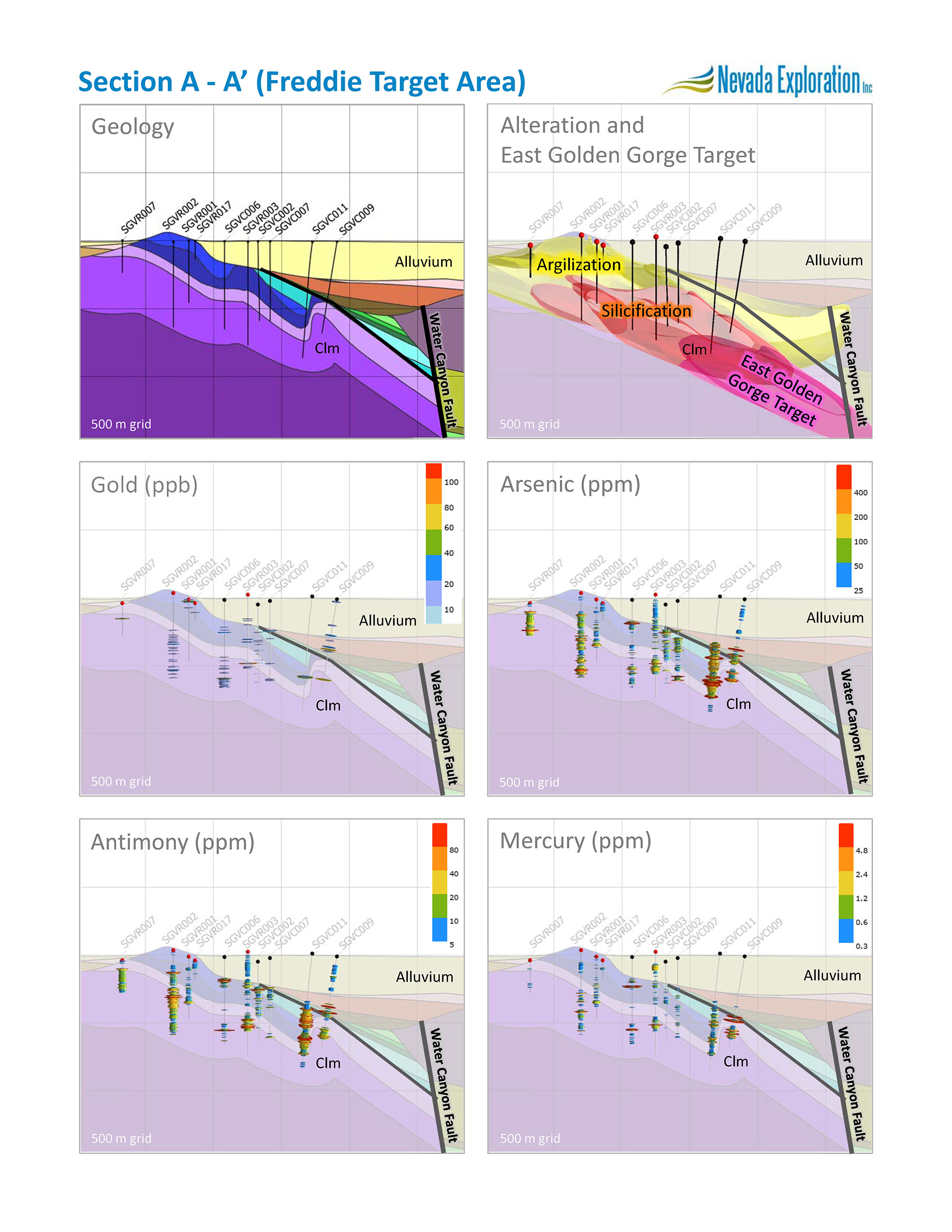
Freddie
Freddie is centred northeast of Goodwin Butte, where initial core drilling defined large zones of sulphide-bearing, silicified breccias within silty carbonate units that showed evidence of low-angle thrust faulting. These favourable host units sit below a shale cap rock at the intersection of major structural features along an antiformal fold hinge, which together represent a characteristic combination of host rocks and mineral controls for CTGD mineralization. The target is supported by elevated gold and related pathfinders within the silicified breccias, as well as by strong overlying geochemistry anomalies in soils and groundwater. NGE’s objectives for the RC drilling program were to determine the extent and controls of the alteration features seen in the core drill holes, and to test their shallower, up-plunge, extension towards the west and north for increasing gold and Carlin-type pathfinders.
NGE completed five RC drill holes in and around the Freddie target area for a total of 1,960 metres. With these RC drill holes, NGE was specifically aiming to collect samples of a Cambrian-aged limey mudstone containing sedimentary debris flows and turbidite breccia units (the “Clm Unit”) that sits immediately below a less-permeable and less-chemically-reactive laminar shale and calcareous siltstone unit. Based on the intensity of silicic alteration and Carlin-type pathfinders, the results of the earlier core drilling suggested the Clm Unit had seen the most hydrothermal fluid flow. Four of the five RC drill holes encountered at least the top of the Clm Unit (all except SGVR017), and two of the holes tested all or most of the full thickness of the unit (SGVR002 and SGVR003).
Collectively, the results of the RC drill holes have confirmed that the Carlin-type alteration features seen in the initial core drilling extend another kilometre to the WNW, which provides additional evidence of the massive scale of the mineral system at the project. The results of the RC drilling also further confirm that the intensity of both the alteration and Carlin-type pathfinder geochemistry is strongly related to the Clm Unit, consistent with what was seen in the earlier core holes. In terms of testing the up-plunge (westward) extension of the alteration features, the zonation and decreasing intensity of the alteration seen in the RC drill holes, as well as the decrease in the relative concentrations of Carlin-type pathfinders, provide multiple vectors, all of which point to a source direction for the mineralized fluids back towards the east, having most likely followed the Clm Unit upwards, along dip from the direction of a major structural feature that NGE refers to as the Water Canyon structural corridor, which as detailed below, defines the eastern boundary of Company’s East Golden Gorge target area
In summary, based on the combined evidence from the core and RC drill holes, NGE believes that the mineralized hydrothermal fluid flow at Freddie was predominantly stratigraphically controlled within the Clm Unit, and that the source direction for this lateral flow was from the east, down dip, from the direction of East Golden Gorge. Having established these likely important controls for mineralization, with NGE’s next drilling program, the Company expects to use deeper core drill holes to follow the projection of the Clm unit down dip, eastwards, closer to what the Company believes is the likely source of the mineralized hydrothermal fluid flow.
Waterfall
Waterfall is located within lower-plate bedrock, now known to be sitting directly on top of the Grass Valley Stock, at the projected intersection of high-angle NW and NE-trending faults. The target was supported by early evidence that a component of the high concentration of gold in groundwater centred over Golden Gorge could potentially have originated upstream from the Waterfall area, as well as by moderately elevated arsenic in soil across the western part of the target. The target concept to test at Waterfall was that of fracture-controlled mineralization within hornfelsed lower-plate. NGE’s objectives for the RC program were to define the interface between the lower-plate and the Grass Valley Stock in this area, and to test this geologic setting for evidence of mineralization.
NGE completed a NE-SW fence of three RC drill holes (SGVR004, SGVR009, and SGVR010) along the northwestern edge of the target, for a total of 966 metres. The three holes encountered a thick section of the projected favourable carbonate host rocks, including the Clm Unit, above large areas of the Grass Valley Stock, which confirms their up-dip projection to the west. While the holes did encounter anomalous CTGD pathfinder geochemistry, the concentrations at Waterfall are considerably lower and less consistent than those seen at Freddie and Golden Gorge to the east, and are associated with much weaker alteration features. Furthermore, the results of the more-detailed 3D groundwater sampling provided by the RC drilling also show that the high concentrations of gold in groundwater seen in the Golden Gorge area do not continue this far west to Waterfall.
Altogether, the gold and Carlin-type pathfinders in the bedrock and groundwater samples from the RC drilling at Waterfall show significantly lower concentrations compared to those seen to the east. With the improved understanding of the geology at Waterfall it appears that the favourable lower-plate host units at Waterfall were likely separated from hydrothermal fluid flow from the east.
In summary, the RC drilling results do not support additional work in this area. Rather, the results at Waterfall, notably the major contrast in terms of gold and pathfinder concentrations between Waterfall and Golden Gorge, further emphasize the importance of establishing the edge of the intrusive, which marks the boundary between the two target areas, in understanding the controls for mineralization across the project. In this case, the intrusive appears to have blocked the lateral flow of mineralized fluids from reaching the Waterfall target area.

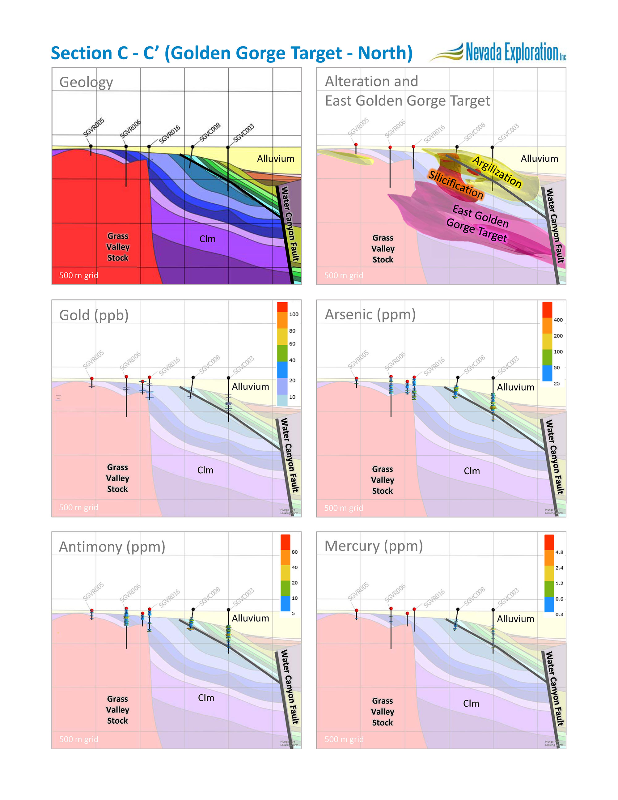
Golden Gorge
Golden Gorge is located to the east of the Grass Valley Stock, where NGE’s earlier core drilling confirmed the presence of anomalous gold and CTGD pathfinders within silicified and marbled breccias along the intrusive margin. The target is supported by the coincident alignment of the highest gold-in-groundwater concentrations seen at the Project, which closely map the interface between the lower-plate bedrock units and the intrusive. NGE’s objectives for the RC drilling program were to establish the extent of and test for mineralization within the hornfels aureole on the east flank of the intrusive, as well as to test the western, up-dip extension of favourable alteration and geochemistry features seen in the earlier drilling.
NGE completed seven RC drill holes at the Freddie target area for a total of 1,470 metres. With these holes, NGE was specifically aiming to accurately establish the edge of the intrusive, and then to sample the lower-plate bedrock units along its margin. Additionally, with an improved understanding of importance of the Clm Unit based on the drilling results at Freddie, the Company was also aiming to complete the RC drill holes at Golden Gorge deep enough to sample this unit. NGE began drilling at the western edge of the target, moving eastward. Four of the westernmost holes proved to be located on top of the granite. The other three drill holes (SGVR006, SGVR015, and SGVR016) successfully entered and sampled lower-plate bedrock along the intrusive, with SGVR006 and SGVR015 exhibiting significant hornfelsization.
In terms of testing for mineralization within the hornfels aureole, while the shallower-than-expected drill holes only sampled a portion of this vertical zone, they encountered significant silicification associated with highly-anomalous Carlin-type pathfinder geochemistry, which most notably included a 52-metre interval in SGVR015 averaging 200 ppm arsenic and 145 ppm antimony. The location and relative intensity of the alteration and pathfinders seen in the drill holes at Golden Gorge suggest the presence of localized vertical fluid flow along the intrusive margin, which could represent an important setting for mineralization, consistent with the Company’s original target concept, though at depths below where the RC drill holes could test. Beyond the hornfels aureole, the general intensity of alteration and geochemistry seen in the Golden Gorge drill holes increases at depth and towards the east, as also seen to the north at Freddie, consistent with mineralized hydrothermal fluids being sourced from the Water Canyon structural corridor.
In summary, compared to Freddie, Golden Gorge is located closer to the Water Canyon structural corridor to the east, and bounded to the west by the Grass Valley Stock. Together, NGE believes these features focused the mineralized hydrothermal fluid flow to a narrower volume of bedrock in this area of the project, which is often favourable for depositing gold. Like at Freddie, NGE believes the source direction of the lateral flow of mineralized fluids at Golden Gorge was down dip to the east, from the East Golden Gorge area, and that the dominant control for fluid flow was likely the Clm Unit. Accordingly, in this area of the project, just as at Freddie to the north, NGE expects its next drilling will test the down-dip projection of the Clm Unit, closer to the likely source of the mineralized hydrothermal fluid flow. Also, based on the evidence for a vertical component to the fluid flow within the hornfelsed lower-plate along the margins of the Grass Valley Stock, NGE expects to continue to include this area in its next phase of work, particularly where the fluid-controlling Clm Unit intersects the intrusive.

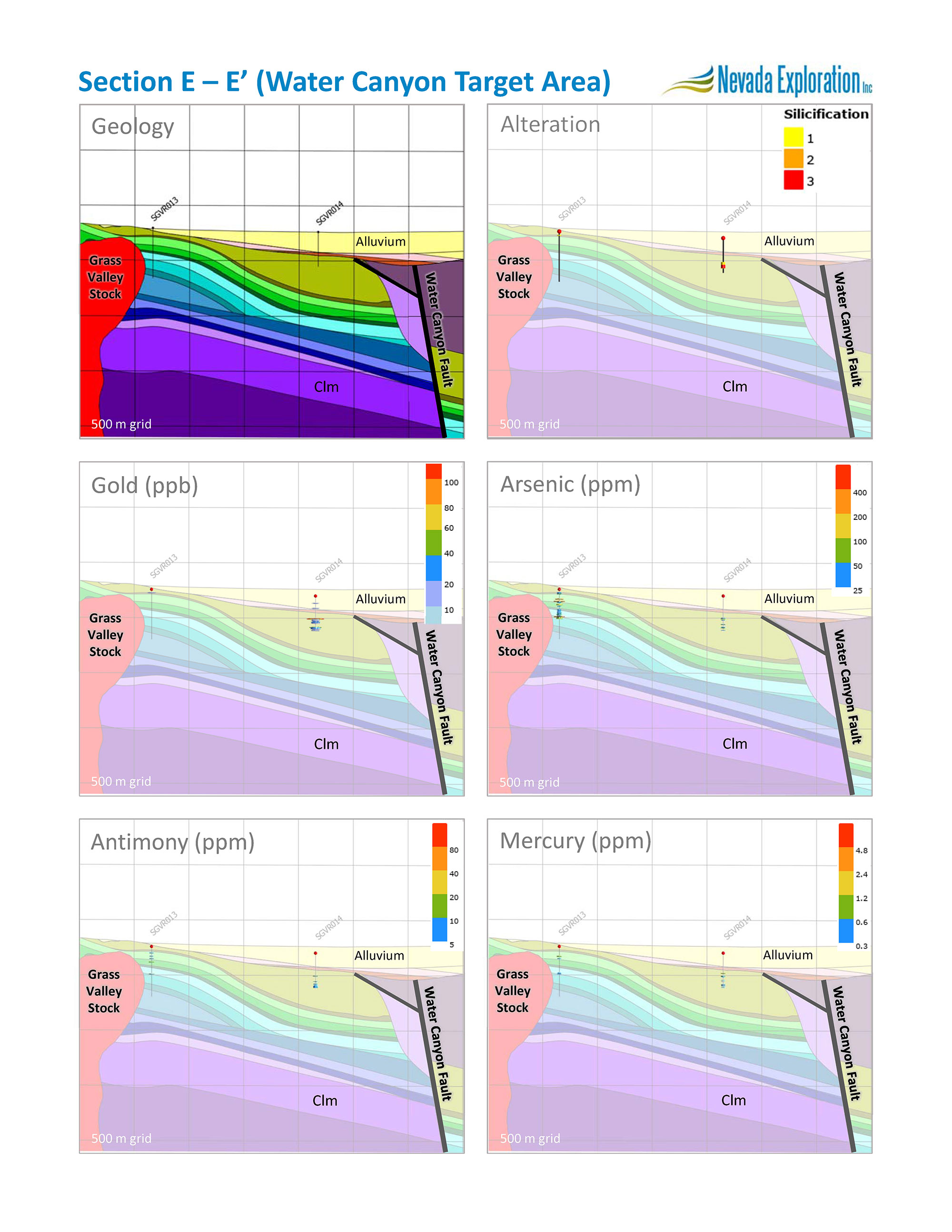
Water Canyon
The Water Canyon target area is located at the south end of the project, west of the Water Canyon structural corridor, at the projected intersection of multiple structural features, east of an historic adit and trench workings exposed in outcrop. The target is supported by elevated Carlin-type pathfinders in soil and groundwater.
The planned RC drilling program represented a large, two-kilometre step out southward from the initial core holes, along the projection of the favourable geologic features that run parallel to the Water Canyon structural corridor. The program also provided an opportunity to sample Roberts Mountains Formation units, a lower plate unit that sits higher in the stratigraphy than the majority of the lower-plate units seen further to the north. NGE’s objectives for the program were to test for evidence of hydrothermal fluid flow in Roberts Mountains Formation units, as well as for gold and related pathfinders within hornfelsed lower plate close to the Grass Valley Stock.
NGE completed two RC drill holes (SGVR013 and SGVR014) in the Water Canyon target area for a total of 590 metres. SGVR013 entered Roberts Mountains Formation under shallow gravel cover, right up against the Grass Valley Stock, and proceeded to alternate in and out of lower plate and granite. Compared to SGV013, in addition to deeper cover, SGVR014 encountered a mudflow unit sitting on top of the lower-plate Roberts Mountains Formation units, which continued until the bottom of the hole.
In terms of testing for hornfels-related mineralization close to the intrusive, SGVR013 encountered narrow intervals of elevated pathfinder geochemistry (e.g. 4.5 metres averaging 299 ppm arsenic) that confirmed there were likely structurally-controlled zones of mineralized fluid flow in this area, but did not encounter much thicker intervals indicative of the scale of fluid flow seen in the hornfels at Golden Gorge. In terms of sampling the Roberts Mountains units, SGVR014 intersected fracture-controlled silicification and anomalous pathfinders that confirm some mineralized fluids reached these upper units, but the alteration and geochemistry were not comparable to the those in the deeper units further to the north.
Beyond testing the lower-plate, the drill holes sampled the alluvium and bedrock above the lower-plate, including the mudflow unit that sits on top of the lower-plate. Of particular note, the mudflow in SGVR014 contained what appear to be mineralized boulders similar to those seen in the mudflow unit further to the north in the initial core holes, which contained anomalous gold and pathfinders. One 4.5-metre mudflow interval in SGVR014 averaged 101 ppb gold. As each assay represents an average concentration over a sample interval, the Company expects that the mineralized boulders may contain higher concentrations. Based on NGE’s modelling of the Paleozoic surface, the Company believes the boulders are representative of lower-plate bedrock that was exposed at the surface at the time the mudflow was deposited, and that the source direction for the mudflow was from the south, which suggests that the mineralized boulder material originated even further south than the Water Canyon target area, and importantly, that parts of the mineralization, only seen at depth to date, were exposed at surface at some point.
In summary, the two shallow drill holes provided limited support for mineralization in the Roberts Mountains formation and an incomplete test of the intrusive margin. What the narrow intervals of alteration and elevated pathfinders have provided, however, is early evidence that the fluid flow responsible for the East Golden Gorge target could extend this far to the south – in which case, the shallower units tested at Water Canyon were likely peripheral to the main fluid flow, suggesting any mineralization in this area is likely deeper or closer to Water Canyon structural corridor, in the direction of where East Golden Gorge projects towards the south. Separately, the mineralized boulders in the mudflow provide a second line of evidence that supports the possibility that the mineralization associated with East Golden Gorge extends further to the south, and possibly shallower. Work at this southern end of this district-scale project remains very early stage, and NGE expects that improved geologic information from next-stage drilling at East Golden Gorge will help guide any additional work in this area.
East Golden Gorge
By integrating the results of its drilling with the results of its air magnetic and gravity geophysics surveys, working with Mira Geoscience, NGE has built a constrained inversion model to refine its understanding of the likely features responsible for a NNW lineament seen in both the gravity and air magnetics. To answer these questions, the modelling specifically focused on: (1) mapping the top of the lower-plate bedrock; (2) refining the geometry of the Grass Valley Stock; and (3) defining the extent of a magnetic mudflow unit encountered in the drilling above the lower plate.
As shared in the Company’s drilling update news release dated March 2, 2020, the results of the inversion modeling show a linear, canyon-like topographic feature in the lower-plate surface that NGE believes marks a regional-scale, high-angle fault system that the Company has named the Water Canyon structural corridor. The modelling also shows that the extent of the magnetic mudflow unit is largely controlled by this canyon-like feature, consistent with how a mudflow would likely behave when constrained by this type of topography, which provides secondary support for the presence of the structural corridor. These types of major structural features represent critical, deep-seated, primary fluid pathways at Nevada’s major CTGD camps, such as the Post-Gen fault that cuts through the northern Carlin trend. NGE believes that establishing the presence and location of the Water Canyon structural corridor is a critical step in understanding the source of mineralized hydrothermal fluids and their subsequent secondary flow across the district.
Based on the combined results of the core and RC drilling programs, the zonation and intensity of the alteration and pathfinder concentrations, particularly as seen at Freddie and Golden Gorge, provide multiple lines of evidence that the source direction for hydrothermal fluid flow was from the east at depth, consistent with the Water Canyon structural corridor providing a primary source of mineralized fluids for the district. The combined drilling results also show that within the sequence of potentially-favourable lower-plate host units that dip eastward toward the Water Canyon structural corridor, the alteration and their associated increase in Carlin pathfinders are most concentrated within the Clm Unit, which NGE believes represented a dominant, stratigraphic, secondary control for the hydrothermal fluid flow.
With this improved understanding of the potential controls for mineralization across the district, NGE believes that the alteration features seen at Freddie, Golden Gorge, and potentially Water Canyon, are the shallower expressions of the hydrothermal fluid flow that followed the Clm Unit westwards and upwards from the Water Canyon structural corridor. NGE expects that following the Clm Unit down dip towards the Water Canyon structural corridor will form the dominant theme for the next phase of exploration. NGE has named this common deeper target area, which is bounded to the east by, and runs parallel to, the Water Canyon structural corridor, East Golden Gorge. The target concept at East Golden Gorge is that of stratigraphically-controlled mineralization within the Clm Unit. The Company is now designing a next-staged drilling program to test East Golden Gorge for increasing grades of CTGD mineralization, and looks forward to sharing its plans with its stakeholders over the coming weeks.
As NGE continues to advance the Project, per NI 43-101, 2.3(2), the Company must remind its stakeholders that the Project remains an exploration target for which the potential quantity and grade of any mineral resource is still conceptual in nature. There has been insufficient exploration to define a mineral resource, and it is uncertain if further exploration will result in the target being delineated as a mineral resource.
About Nevada Exploration Inc.
With mature, exposed search spaces seeing falling discovery rates, NGE believes the future of exploration is under cover.
The Company has spent 15 years developing and integrating new hydrogeochemistry (groundwater chemistry) and low-cost drilling technology to build an industry-leading, geochemistry-focused, under-cover toolkit specifically to explore for large new Carlin-type gold deposits (“CTGDs”) in the more than 50% of Nevada where the bedrock is hidden beneath post-mineral cover. Nevada’s exposed terrains have produced more than 200 Moz of gold, and experts agree there is likely another +200 Moz waiting to be discovered under cover in Nevada.
NGE has completed the world’s largest hydrogeochemistry exploration program, focused on north-central Nevada, and is now advancing a portfolio of three district-scale projects in the heart of the Cortez (Battle Mountain-Eureka) Trend.
NGE’s most advanced project is South Grass Valley, located south of Nevada Gold Mines’ Cortez Complex. Based on the Company’s work to date at the project, NGE believes it has discovered a mineral system at South Grass Valley with the architecture and scale to support multiple Carlin-type gold deposits (CTGDs), and the potential to host an entire new district. NGE believes South Grass Valley is one of the most exciting new district-scale, Carlin-type projects in Nevada.
For more information, the Company’s latest videos are available at:
https://www.nevadaexploration.com/investors/media/
For further information, please contact:
Nevada Exploration Inc.
Email: info@nevadaexploration.com
Telephone: +1 (604) 601 2006
Website: www.nevadaexploration.com
Neither the TSX Venture Exchange nor its Regulation Services Provider (as that term is defined in the policies of the TSX Venture Exchange) accepts responsibility for the adequacy or accuracy of this release.
Wade A. Hodges, CEO & Director, Nevada Exploration Inc., is the Qualified Person, as defined in National Instrument 43-101, and has prepared the technical and scientific information contained in this News Release.
Cautionary Statement on Forward-Looking Information:
This news release contains “forward-looking information” and “forward-looking statements” (collectively, “forward-looking information”) within the meaning of applicable securities laws, including, without limitation, expectations, beliefs, plans, and objectives regarding projects, potential transactions, and ventures discussed in this release.
In connection with the forward-looking information contained in this news release, the Company has made numerous assumptions, regarding, among other things, the assumption the Company will continue as a going concern and will continue to be able to access the capital required to advance its projects and continue operations. While the Company considers these assumptions to be reasonable, these assumptions are inherently subject to significant uncertainties and contingencies.
In addition, there are known and unknown risk factors which could cause the Company’s actual results, performance or achievements to be materially different from any future results, performance or achievements expressed or implied by the forward-looking information contained herein. Among the important factors that could cause actual results to differ materially from those indicated by such forward-looking statements are the risks inherent in mineral exploration, the need to obtain additional financing, environmental permits, the availability of needed personnel and equipment for exploration and development, fluctuations in the price of minerals, and general economic conditions.
A more complete discussion of the risks and uncertainties facing the Company is disclosed in the Company’s continuous disclosure filings with Canadian securities regulatory authorities at www.sedar.com. All forward-looking information herein is qualified in its entirety by this cautionary statement, and the Company disclaims any obligation to revise or update any such forward-looking information or to publicly announce the result of any revisions to any of the forward-looking information contained herein to reflect future results, events or developments, except as required by law.